Starting place: the Coupure canal
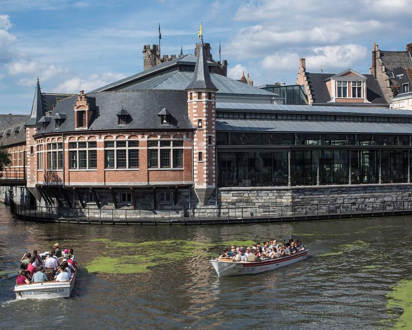
This is where the Austrian Imperial Warehouse used to be in the 18th century. The canal itself was dug to connect the river Lys in the city centre to the Ghent-Bruges-Ostend Canal at the time of the Spanish Rulers Albert and Isabella, who was the daughter of Spanish king Philip II and granddaughter of emperor Charles V. The 17th-century canal had its terminus at the Bargie quay. The name of the Coupure canal comes a French word which means “cut”. This is because it was constructed as a kind of shortcut.
We follow the river Lys upstream; to the right, we pass under the Verlorenkostbrug bridge.
Gloriettes
When you leave the Coupure canal, turn right upstream into the river Lys. You’ll see a little teahouse or gloriette on your left. The owners of grand town houses had these elegant annexes constructed in their gardens. They were built in a time when mansions had a smoking lounge for the gentlemen and a boudoir for the ladies. These gloriettes were used for having afternoon tea.
Jozef Kluyskens
The first street on the right is called Professor Kluyskensstraat. Ghent University was founded in 1817 and is now the biggest university in Belgium. Of course, it has always included a Faculty of Medicine. Jozef Kluyskens was a surgeon just like his father and was able to use his knowledge at the Battle of Waterloo. He is said to have performed about 300 amputations in that period. He was also one of the University's very first professors.
In Jozef Kluyskensstraat, you can see a very beautiful neo-Gothic building on the left, which was designed by architect Cloquet and is called the Rommelaere Institute (1899). It was once known as the Forensic Medical Institute where autopsies were performed. The same architect also designed the Post Office and St Michael's bridge next to it, as well as the Gent-Sint-Pieters railway station.
Across the street, you can see the Civil Hospital, designed and built by architect Pauli between 1864 and 1880. This is the neo-Gothic part of the Bijloke hospital and convent. It’s no longer a hospital, but a training centre for filmmakers and directors, namely the Royal Academy of Fine Arts (KASK).
Veergrep
On the left, you navigate along the slope towards Kortrijksepoortstraat. Here, working-class families lived in small houses around enclosed courtyards. This courtyard was called Veergrep. It’s a remnant of the many enclosed courtyards that were scattered across the city, where workers lived in appalling conditions. The City of Ghent has a plan to save the last courtyards from being demolished.
Het Craekhuis
On the right, you can see the gabled roof of Craekhuis. This building was built against the Oude Bijloke hospital ward. Craekhuis was the palliative department of the hospital behind it, built in the early 1300s in Tournai limestone and with a magnificent trefoil arch in the gable. The beautiful hospital ward and Craekhuis have been restored and are now used as a concert hall. The Ghent City Museum or STAM consists of the former convent and the chapel as well as a newly built exhibition space.
The foundation of the convent and the hospital date back to 1204, when rich patrician Ermentrude Utenhove founded a hospice, where Cistercian nuns cared for the sick.
The name Bijloke means enclosed piece of land; the monastery itself was named Portus Mariae or Mary’s Resort.
Jan Palfijn
Now pass under the Jan Palfijnbrug bridge, named after the surgeon who improved the forceps and made them known to the public. The forceps were already used in England, but barber surgeon Chamberlene performed deliveries with forceps under a blanket in order to keep the instrument a secret. Jan Palfijn spent the majority of his career working at the Bijloke Hospital. The brand-new Palfijn Hospital is located about two kilometres from here.
You can see the Blandijnberg hill on your left, which is an ancient hill of about 29 metres, where Saint Amand founded St Peters' Abbey in the 7th century. In the same period, he also founded the Ganda Abbey, now called St Bavo's Abbey, at the confluence of the Lys and the Scheldt. Ganda is a Celtic word which means “confluence”.
Henleykaai
Now navigate along Henleykaai. That name was given to this quay with great pride in 1906, when the rowers of Club Nautique, now the Royal Ghent Rowing Club, won the world's most prestigious rowing competition, the 'Grand Challenge Regatta of Henley’.
On the right, you can see the modern building of the Trade and Language Institute, which was designed by architects Tanghe and Serck.
On the left is a small concrete quay that used to belong to coal merchant Bracke Campens. Until the 1960s, barges carrying mostly Belgian coal were unloaded here.
From then on, there was a slow transition to gas and electricity for heating systems.
Now pass under the Koning Albertbrug bridge.
Gordunakaai
The left bank here is called Gordunakaai. The Gordunes were an ancient tribe that lived here at the time of Julius Caesar. If you pass under the Europabrug bridge, you'll see a branch of the river Lys. It runs through the Watersportbaan sports facilities and flows into the Ghent-Bruges-Ostend Canal some three kilometres further on. The route runs parallel to the avenue called De Nieuwe Wandeling, notorious for being the location of the National Prison.
Watersportbaan Georges Nachez is a rowing course, two and a half kilometres long and 76 metres wide, where many national and international regattas take place.
Patyntje
On the left, you pass the restaurant Patyntje, named after its surrounding neighbourhood. The name signifies “end of the path”. The restaurant was built in the early 1900s and used to be the favourite restaurant of German officers during the First World War. This restaurant still has the character of what the French call guinguettes or open-air cafés. Some of these, located on the banks of the Seine, have become world-famous thanks to Renoir's painting Le Déjeuner des Canotiers or Luncheon of the Boating Party.
Sneppenbrug-Krommehambrug
Continue under the Sneppenbrug bridge and navigate between the boats of the yacht clubs. The river turns rights and you pass under the bridge of the ring road around Ghent (R4). Now you have to be careful because you have to cross the Ringvaart canal. This bridge is called Krommehambrug. Barges of up to 4,500 tonnes can navigate here. Inland navigation was promoted through the extension of the Ringvaart canal in the 1950s-1960s. In the same spirit, the Seine/Scheldt connection now ensures that there are thousands of trucks less on our roads. This is a plus for reducing pollution and avoiding congestion. Go straight ahead. On the right is the connection to the Ghent-Bruges-Ostend Canal and to the port of Ghent (which has merged with Terneuzen and is now called North Sea Port) and the port of Antwerp. On the left, you can see the Merelbeke lock complex and you can follow the river Scheldt upstream.
Adolphe Pégoud
The first bends are coming up. On your left, you can see the villas of Sint-Denijs-Westrem on the banks of the Lys. There’s a little park in between these villas where you can see a public bench. This square has a lot of history. The Ikea store and the 90 metre tall KBC tower are located across the road and the railway. A racecourse used to be located here in the 19th century. In November 1913, it was converted into an airfield for the 1913 World’s Fair. Adolphe Pégoud, who was a French stunt pilot and the first to ever dare to perform a looping, was invited. He performed seven loops in a row in Ghent. The crowds of local Ghent residents couldn’t believe their eyes.
That is why the name of the square is THE LOOP. In 1914, World War I started, the first war in which aeroplanes were deployed. This square was an important air base close to the Yser Front for the Imperial German Air Force.
Sint-Denijs’s airfield was closed in 1985.
Afsnee
The bends in the river Lys have the Assels nature area on the right bank and Leiepark on the left. You slowly discover Afsnee's little Romanesque church on the left. This church has been mirrored in the Lys river for 9 centuries. The village is really old, because in 1910, a stilt village was discovered here. The church dedicated to Saint John the Baptist is also centuries old. The stones used to build this church are limestone from Tournai. These stones were used to build all of Ghent's oldest buildings, including the Castle of the Counts and the Belfry. It wasn’t until the 15th century that people started using sandstone from Balegem for construction. The church is an example of a three-aisled cruciform church with a crossing tower. The enclosed cemetery surrounds the church and the old village school is located across the street.
The village itself has kept its charm with the old presbytery and the Daerupt manor behind the church, which was mentioned for the first time in documents from the 14th century.
Restaurant Nénuphar
Restaurant Nénuphar has been a household name in and around Ghent since de 19th century. You could reach it on foot, by carriage, by horse or by boat from Ghent. Perhaps the French influence of Ghent’s bourgeoisie is the reason why its name is not Water Lily but the French word Nénuphar. Afsnee and Sint-Martens-Latem have been widely reputed as artists' villages since the second half of the 19th century. You can find beautiful paintings by Gustave De Smet in Nénuphar. Some other painters who were inspired by the Lys landscape were Albijn (Binus) Van den Abele, Valerius De Saedeleer, Saverijs, Servaes, Xavier and César De Cock, Permeke and Emile Claus.
Holy House
The boat route continues and the Lys has some narrower passages. When navigating through the fields, you can see a branch of the Lys on your right. It leads to the former Norbertine abbey of Drongen, whose cupola on its tower can be seen in the distance. Do not take the branch of the Lys on your right-hand side as it is a dead end. The fork in the river is called “Drie Leien”. On the right, there are jetties and you can see the smaller houses of the Assels neighbourhood. You can continue until you see the floating clubhouse of yacht club LSV (Leie Snel Vaarders). A little further on, on the same bank, there used to be an inn called Heilige Huizeken (which means Holy House). The innkeepers turned away anyone who dared to curse in their establishment. Hence the name.


